←Select platform
WatershedCommand Class
Summary
Separates the image into different segments using the Watershed algorithm.
Syntax
C#
Objective-C
C++/CLI
Java
Python
public class WatershedCommand : RasterCommand @interface LTWatershedCommand : LTRasterCommand public class WatershedCommandextends RasterCommand
public ref class WatershedCommand : public RasterCommand class WatershedCommand(RasterCommand): Remarks
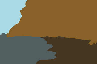
- Each segment's pixels has the same color. The Watershed algorithm treats an image as if it were a topographic surface. The dark areas are basins. The light areas are the ridges around the basins.
- The user is responsible for determining the number of output segments and the location of each segment in the input array.
- This command supports 8, 16-bit grayscale and colored images and 24, 32-bit colored images.
- This command does not support 32-bit grayscale images.
- This command supports signed/unsigned images.
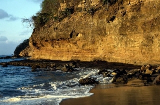
Watershed Segmentation Function - Before

Watershed Segmentation Function - After

View additional platform support for this Watershed Segmentation function.
Example
C#
Java
using Leadtools;using Leadtools.Codecs;using Leadtools.ImageProcessing.Core;public void WatershedCommandExample(){RasterCodecs codecs = new RasterCodecs();codecs.ThrowExceptionsOnInvalidImages = true;//Load an imageRasterImage image = codecs.Load(Path.Combine(LEAD_VARS.ImagesDir, "IMAGE3.dcm"));LeadPoint[][] pointsArray = new LeadPoint[4][];for (int idx = 0; idx < 4; idx++)pointsArray[idx] = new LeadPoint[2];// Set starting point and end point for each segment path.pointsArray[0][0] = new LeadPoint(35, 100);pointsArray[0][1] = new LeadPoint(35, 200);pointsArray[1][0] = new LeadPoint(180, 115);pointsArray[1][1] = new LeadPoint(300, 115);pointsArray[2][0] = new LeadPoint(235, 220);pointsArray[2][1] = new LeadPoint(260, 220);pointsArray[3][0] = new LeadPoint(180, 330);pointsArray[3][1] = new LeadPoint(350, 330);//Prepare the commandWatershedCommand command = new WatershedCommand(pointsArray);//Applycommand.Run(image);}static class LEAD_VARS{public const string ImagesDir = @"C:\LEADTOOLS23\Resources\Images";}
import java.io.File;import java.io.IOException;import java.util.ArrayList;import org.junit.*;import org.junit.runner.JUnitCore;import org.junit.runner.Result;import org.junit.runner.notification.Failure;import static org.junit.Assert.assertTrue;import leadtools.*;import leadtools.codecs.*;import leadtools.imageprocessing.core.*;public void watershedCommandExample() {final String LEAD_VARS_IMAGES_DIR = "C:\\LEADTOOLS23\\Resources\\Images";RasterCodecs codecs = new RasterCodecs();codecs.setThrowExceptionsOnInvalidImages(true);// Load an imageRasterImage image = codecs.load(combine(LEAD_VARS_IMAGES_DIR, "DICOM\\image3.dcm"));ArrayList<ArrayList<LeadPoint>> pointsArray = new ArrayList<ArrayList<LeadPoint>>();for (int idx = 0; idx < 4; idx++) {pointsArray.add(new ArrayList<LeadPoint>());for (int i = 0; i < 2; i++) {pointsArray.get(idx).add(new LeadPoint());}}// Set starting point and end point for each segment path.pointsArray.get(0).set(0, new LeadPoint(35, 100));pointsArray.get(0).set(1, new LeadPoint(35, 200));pointsArray.get(1).set(0, new LeadPoint(180, 115));pointsArray.get(1).set(1, new LeadPoint(300, 115));pointsArray.get(2).set(0, new LeadPoint(235, 220));pointsArray.get(2).set(1, new LeadPoint(260, 220));pointsArray.get(3).set(0, new LeadPoint(180, 330));pointsArray.get(3).set(1, new LeadPoint(350, 330));// Prepare the commandWatershedCommand command = new WatershedCommand();command.setPointsArray(pointsArray);// Applyint change = command.run(image);assertTrue(change != RasterImageChangedFlags.NONE);codecs.save(image, combine(LEAD_VARS_IMAGES_DIR, "DICOM\\Result.dcm"), RasterImageFormat.DICOM_COLOR, 0);System.out.println("Command run and image saved to: " + combine(LEAD_VARS_IMAGES_DIR, "DICOM\\Result.dcm"));}
Requirements
Help Version 23.0.2024.3.3
Products | Support | Contact Us | Intellectual Property Notices © 1991-2025 Apryse Sofware Corp. All Rights Reserved.
Leadtools.ImageProcessing.Core Assembly
